India is home to some of the most diverse ecosystems in the world, with several regions recognized as biodiversity hotspots. The Biodiversity hotspots in India are areas rich in endemic species, which are under threat due to human activities. Understanding biodiversity hotspots is crucial to preserving the rich flora and fauna that thrive in these environments.
What are Biodiversity Hotspots?
Biodiversity hotspots are regions that are biologically rich but highly threatened. These areas are recognized for their exceptional levels of plant and animal species that are unique (endemic) to the region and cannot be found anywhere else in the world. At the same time, they face significant habitat loss due to human activities like deforestation, agriculture, and urbanization.
What are the Criteria for a Biodiversity Hotspots in India?
To qualify as a biodiversity hotspots in India, a region must satisfy two main criteria:-
High Endemism:- The region must have at least 1,500 species of vascular plants as endemics, meaning these species are found nowhere else on Earth.
Severe Habitat Loss:- The region must have lost at least 70% of its original natural vegetation, primarily due to human-induced pressures such as deforestation and development.
Biodiversity Hotspots in India
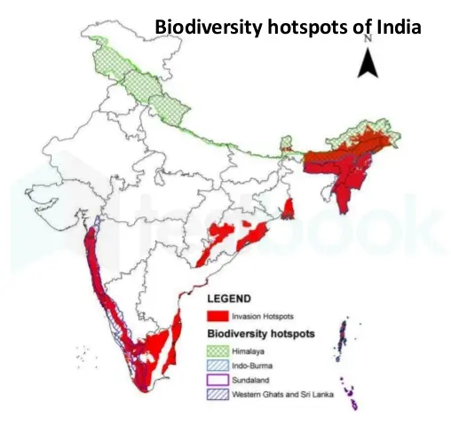
There are four biodiversity Hotspots in India:
- Himalayas
- Indo-Burma
- Western Ghats
- Sundaland
Himalayas
Every of the Earth’s tallest mountains in the world summits, surpassing 8,000 meters, including Mt. Everest (8,849 meters), is located in the Himalayan hotspot, extending over 3,000 kilometers across northern Pakistan, Nepal, Bhutan, and the northwest and northeastern regions of India. Additionally, it boasts some of the world’s deepest river valleys.
The Himalayan Mountain range spans an area of about 7.5 million square kilometers and is segmented into the Eastern Himalaya and the Western Himalaya. The Eastern Himalaya encompasses sections of Nepal, Bhutan, the northeastern Indian states of West Bengal, Sikkim, Assam, and Arunachal Pradesh, while the Western Himalaya covers areas of Kumaon-Garhwal, northwest Kashmir, and northern Pakistan.
The Himalayan ranges support a diverse range of environments, such as:
- Coniferous and mixed forest areas on the steep slopes
- Mountain pastures above the canopy of trees,
- The world’s highest grasslands Mild deciduous forests near the foothills
- Temperate deciduous forests in the middle elevations
Plants with vascular systems have been found even at elevations exceeding 6,000 meters. The hotspot is home to a wide variety of large bird and mammal species, such as vultures, tigers, elephants, rhinos, and free-ranging water buffalo. The global hotspot areas underwent a review and update based on the distribution of species, the level of threats they face, and any changes in the threat levels. It was determined that the Himalayan hotspot is distinct from the Indo-Burma hotspot.
Threats to Himalayan Biodiversity
- Encouraging both foreign immigration and domestic movement, resulting in a significant rise in the human population in areas with the highest biodiversity.
- Due to extensive legal and illegal logging, particularly on steep slopes, coupled with the significant clearing of forests and meadows for agriculture, there has been severe erosio
- During the summer, the area is often burned to clear space for livestock, introducing an additional risk to the forest as fires can sometimes spiral out of control.
- Rapid deforestation and habitat fragmentation have resulted from the conversion of forests and grasslands into agricultural and settlement areas, predominantly in Nepal and the Indian states of Sikkim, West Bengal (Darjeeling), and Assam.
2. Indo-Burma
The Indo-Burma hotspot is the largest of the world’s 36 recognized hotspots, spanning a total area of 2,373,000 square kilometers.
The Indo-Burma hotspot once covered areas in northeastern India, Bangladesh, and Malaysia.
However, Bangladesh, India, and Malaysia are considered peripheral to the hotspot for the purposes of the ecosystem profile, as northeastern India is encompassed within the Himalayan hotspot, and the hotspot only marginally extends into Bangladesh and Malaysia. The hotspot boasts remarkable geographic diversity, spanning from the highest peak in Southeast Asia to coastlines along the Bay of Bengal, Andaman Sea, Gulf of Thailand, and South China Sea.
The Indo-Burma hotspot, characterized by its diverse landforms and climatic zones, supports a wide range of habitats, thereby contributing to a high level of overall biodiversity.
Over the past 12 years, 6 new species of large mammals have been identified in this area.
- Large-antlered Muntjac
- Annamite Muntjac
- Grey-shanked Douc
- Annamite Striped Rabbit
- Leaf Deer
- Saola
The majority of the endemic freshwater turtle species found in this hotspot are at risk of extinction due to overfishing and habitat destruction.
Threats to Indo-Burma
- The primary threats to the biodiversity of this hotspot include logging, over-exploitation of natural resources, industrial agriculture, trade, and consumption of wildlife, the construction of massive infrastructures such as dams, highways, and ports, and climate change.
- In Indo-Burma, commercial timber exploitation ranks second among the causes of deforestation.
- The loss of habitat has impacted various landforms, including wetlands and freshwater floodplain swamps.
- Large tracts of mangroves have been confined within aquaculture ponds, and numerous rivers have been dammed and altered.
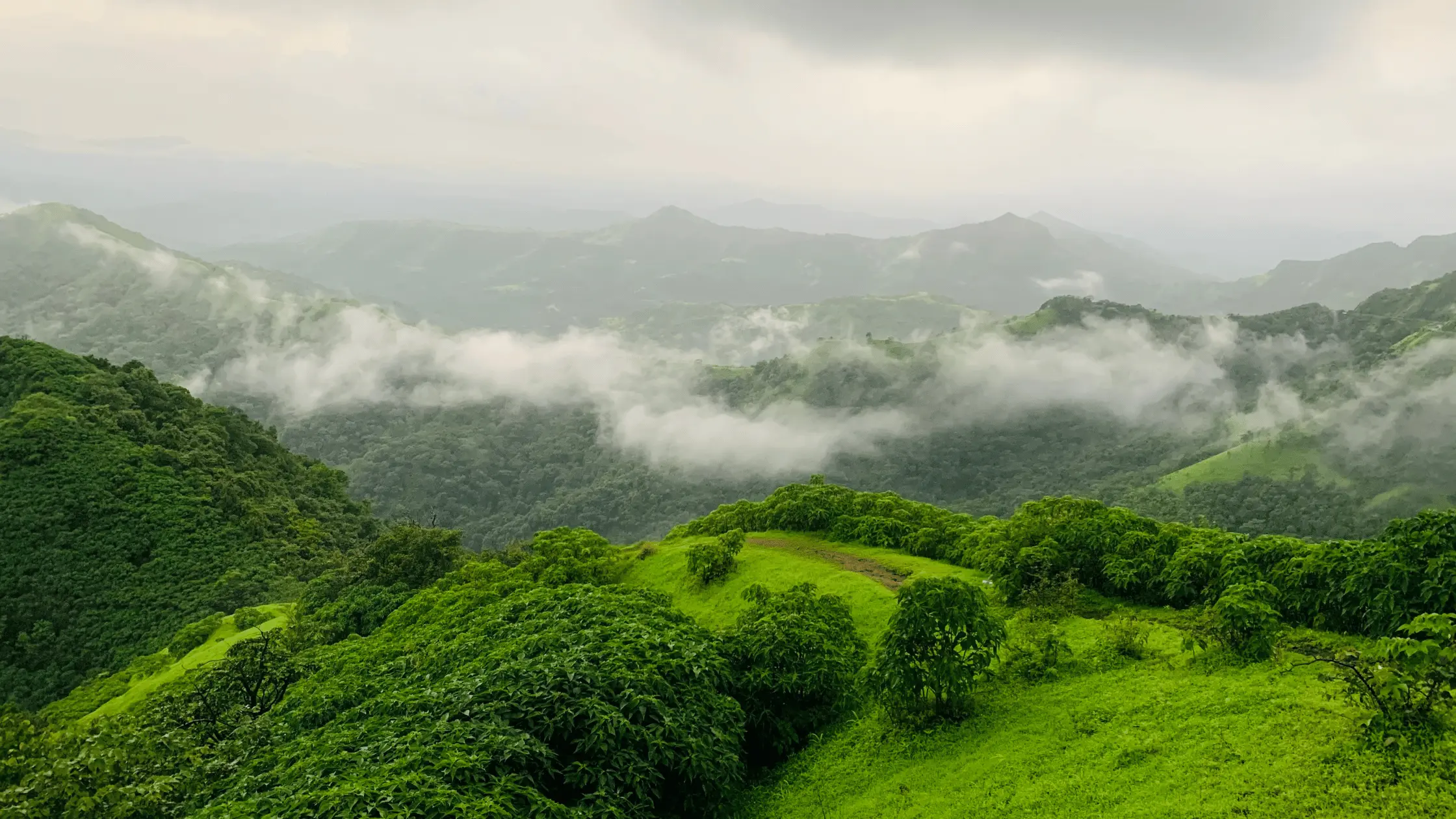
3. Western Ghats
The Western Ghats, also known as the Sahyadri Hills locally, consist of the Malabar Plains and a series of mountains that stretch from 30 to 50 kilometers inland, running parallel to India’s western coast.
Covering a distance of 1,600 km from the southernmost point of the nation to Gujarat in the north, the Western Ghats span just 30 km across the Palakkad Gap. This vast expanse of land, which stretches over an area of more than 160,000 km2, plays a crucial role in regulating the rainfall across peninsular India. By intercepting the southwestern monsoon winds, the Western Ghats effectively control the distribution of rainfall across the region.
Every year, the western slopes of the mountains receive a significant amount of rainfall, with the majority of it occurring during the southwest monsoon period, spanning from June to September. As you move from south to north, the intensity of rainfall decreases. Conversely, the eastern slopes tend to be drier.
Threats to Western Ghats
- The forests of the Western Ghats have been extensively fragmented and selectively logged throughout their entire range.
- Forests have been cleared to make way for monoculture plantations of tea, coffee, rubber, oil palm, teak, eucalyptus, and wattle, as well as to accommodate reservoirs, highways, and railways.
- More forests are being lost due to encroachment into protected areas. On slopes that were once lush with forest, the grazing of cattle and goats inside and near these protected zones is severely eroding them.
- The bulk of the remaining forest cover is constituted by areas of disturbed secondary growth or wood plantations.
4. Sundaland
The Sundaland hotspot covers the western part of the Indo-Malayan archipelago, which has around 17,000 equatorial islands. Borneo and Sumatra are the two biggest islands globally, with areas of 725,000 km2 and 427,300 km2, respectively.
Sundaland covers a large area, including most of Malaysia, Peninsular Malaysia, East Malaysian states like Sarawak and Sabah, Singapore, Brunei Darussalam, and the western part of Indonesia, including Kalimantan. It also includes a small part of southern Thailand, specifically the provinces of Pattani, Yala, and Narathiwat, as well as the Indonesian parts of Borneo, Sumatra, Java, and Bali.
India governs the Nicobar Islands, which are also part of it. The Philippines’ 7,100 islands form the Philippines Hotspot, located northeast of Wallacea. This area is divided from Sundaland Hotspot by the famous Wallace’s Line.
Threats to Biodiversity in Sundaland
- The beautiful plants and animals in the Sundaland Hotspot are quickly being harmed by large-scale tree cutting on these islands.
- Animals like tigers, monkeys, and turtles are traded worldwide for food and medicine.
- Orangutans are only found in this region, and their numbers are quickly decreasing.
- The Indonesian islands of Java and Sumatra are the last remaining homes for two types of Southeast Asian rhinos.
Conclusion
The biodiversity hotspots in India—spanning the Himalayas, Indo-Burma, Western Ghats, and Sundaland—are invaluable ecosystems rich in unique flora and fauna. These regions not only harbor rare and endangered species but also provide vital ecosystem services, contributing to the country’s environmental health and human well-being. However, they face significant threats from deforestation, climate change, and human activities. Preserving these hotspots is crucial for maintaining ecological balance, protecting biodiversity, and ensuring the sustainability of natural resources for future generations. Collective efforts in conservation and sustainable practices are essential to safeguard these ecological treasures.